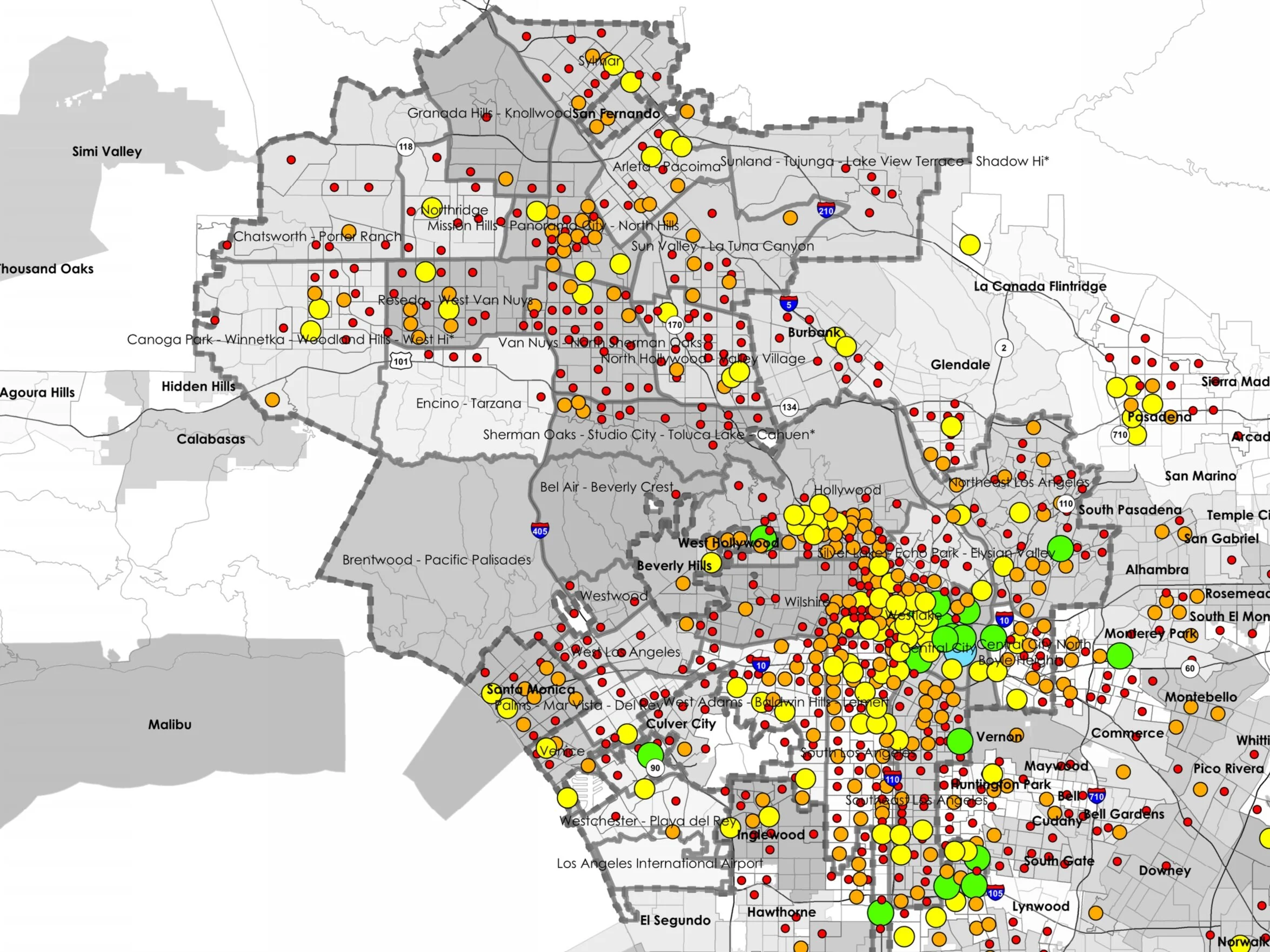
Population, median household income, and dwelling unit count for the Los Angeles Metropolitan Area, City of Los Angeles, City Council District 11 (CD 11), and all Community Plan Areas (CPAs) within CD 11 as reported by the U.S. Census Bureau.
Read MoreHomelessness and housing unaffordability are increasing throughout the Los Angeles area, including City Council District 11 where much of the City’s coastal communities are located. This includes Brentwood-Pacific Palisades, Palms-Mar Vista-Del Rey, West Los Angeles, Westchester-Playa Del Rey, and Venice Community Plan Areas (CPAs).
This whitepaper summarized Pacific Urbanism’s previous and current results from our research on homelessness counts, suitable sites for off street emergency shelter, and an inventory subsidized low income housing units within Los Angeles City Council District 11.
Read MoreOur research has identified ADUs as a best practice for providing naturally occurring affordable housing within the ongoing housing scarcity and unaffordability crisis. Commercial conversions (the conversion of commercial space to a residential use) also present a strategy for supplying housing units during a housing shortage. Mixed-use developments are common place in urban areas globally, and the COVID-19 Pandemic has revealed opportunities for underused retail and office spaces.
Read MoreOpportunities for furthering fair housing through community economic development and a potential new empirical method for allocating housing needs, targets, and allowable density using a spatial composite index of scores to correct for past exclusionary zoning practices, housing price inflation, vehicle miles travelled, and disparities in opportunities and resources. Relief from hindrances to production and public policies that untie the hands of local community, need-driven homebuilders, are identified as a bridge between current housing trends and the State and Regional Housing Needs Assessment Goals for 2029.
Read MoreThe data presented in the Center’s research and publications are sourced from several publicly available datasets and supplemented by interviews and public comments where appropriate. This publication is a compilation of publications and presentations recently conducted by the Center for the purposes of advancing the five main objectives, as well as citations for the datasets used.
Read MoreThe Center for Pacific Urbanism collaborates with members of Historic Venice and the Oakwood community to further efforts of self-determination through analyses of US Census Bureau and Office of the Tax Assessor data, an inventory of housing stock by decade and building type, Zoning trends, and alternative scenario development. The normative state as defined by the community is the guiding principle, the rest is history.
Read MoreThe Center for Pacific Urbanism has inventoried potentially suitable sites for homeless off street sanctuary using GIS and other planning support tools, sorted by feasibility according to developing criteria. This report publishes the most recent suitable sites analysis for homeless sanctuary ranked by a composite score that takes into account size (site area), density of unsheltered individuals, road access, topographic slope, proximity to fire hydrants and sewer, market rate of land, ecology, and land use compatibility.
Read MoreThe Atlantic writer Conor Friedersdorf cites Pacific Urbanism’s census data and population growth analysis for the Venice Community Plan Area in this article regarding the history of urban development and land use in the State of California.
Read MoreA summary of several historical trends including housing affordability, homelessness, census data, housing stock, dwelling unit production, downzoning, commuter trends, and economic profiles for the Venice Neighborhood Council and City of Los Angeles Council District 11
Read MoreAlternatives to our unhoused neighbors sleeping on the streets is within reach, spatially and financially feasible, and our collective responsibility. This includes City Council and the Department of City Planning addressing the root causes that continue to drive homelessness rates: housing scarcity, barriers to supply, and a fair share approach by every community. In 2020 Council District 11 counted close to 3,300 total homeless, a 40% increase from the previous year. Rather than continue down the path of housing scarcity at all income levels, neighborhood communities, their elected representatives in City Council, staff, and others, can and ought to contribute to a community based alternative to sleeping on the street. The Homeless Off Street Sanctuary initiative is one such alternative that identifies suitable government owned land Countywide, in a hub and satellite network arrangement, at a cost that is one tenth that which is currently being incurred.
Read MoreA summary of several historical trends including housing production, changes in demographics, housing price, and commuter vehicle-miles-travelled, as well Pacific Urbanism’s recommendations for the future of urban development in Council District 11 and Westside Los Angeles.
Read MoreLos Angeles has a housing affordability crisis due in large part to a lack of supply that is five to six decades in the making. The root causes in Los Angeles include suppressed housing supply rates due to inequitable urban planning and exclusionary zoning, such as downzoning, inadequate policies or enforcement, rising construction and development costs, a financial structure favoring nonresidential development, and insufficient funding for subsidized low income housing.
The big planning question with which we have been grappling is whether any zoning changes are either necessary, or more conducive to, accomplishing the 8 year targeted increase in housing supply, and if so, what specific zoning changes are these?
Read MoreToday, housing production in Los Angeles overall is eight times less than what it ought to be in order to bridge the housing shortage. Affordable housing production is less than a twentieth of the necessary supply rate to make up for over half a century of inequitable housing policies. While fiscal resources are being expended and depleted at unsustainable rates, the cost of housing continues to rise and the number of households falling into homelessness continues to increase
Read MoreIn order to meet housing targets set by the Southern California Association of Governments (SCAG), Pacific Urbanism proposes a comprehensive, holistic approach to land use and zoning designations amongst Community Plan Areas (CPAs) in Los Angeles.
Read MoreTransit-oriented communities (TOCs) are a land use policy adopted by the City of Los Angeles which anticipate higher production of housing within specified boundaries. Advocates for TOC claim this strategy is a viable solution to the meet the City's housing needs. However, housing production from TOC is far below the total units needed in the City.
Read MoreThe Mello Act sets requirements for the demolition, conversion and construction of housing in the Coastal Zone and applies to the Coastal Zone throughout the entire state of California. The primary objective of this paper is to evaluate what the impacts of changes to the Mello Act would be within the Coastal Zone in the City of Los Angeles.
Read MoreSubsidized low income housing units, often referred to as “affordable housing”, are housing units in which rental costs are partially or wholly subsidized by public funds and agencies. These units are intended to provide support for households who are overburdened by rent but also service senior citizens, individuals with severe mental health conditions, people with physical disabilities, and others who require similar assistance. As such, knowing the total amount and location of these units is imperative to understanding the current status of affordable housing in Los Angeles, as well as the creation of future policy surrounding affordable housing and overall dwelling unit production citywide.
Read MoreCommercial use (along with residential, industrial, open space, and various other uses) is a major component of land use policy and zoning laws. Properties zoned for commercial use often include shopping malls, wholesale retail stores, offices, financial establishments, entertainment centers, and other similar businesses. Due to this, commercially zoned areas are of particular importance to better understanding local and regional economies. Whereas recommendations for the intensity and areas of commercial use in Los Angeles have been published elsewhere, this paper builds upon a growing body of academic and policy research that evidences growing opportunities in all neighborhoods for community economic development.
Read MoreAs Los Angeles continues to face a worsening housing scarcity and unaffordability crisis, we must determine and implement policies that will help our neighbors avoid homelessness by providing adequate shelter and housing both in the immediate as well as permanently. This study provides a comprehensive list of potential sites for off-street homeless shelters in Los Angeles as well as an inventory of precedents from various cities that should be considered by local policymakers in addressing homelessness in our communities.
Read MoreDownzoning is the practice of reducing an area’s dwelling unit capacity, whether by forbidding or limiting multiple-family dwellings, or through restrictive regulations, such as increased parking requirements, larger minimum lot sizes and building setbacks.
Read More


